
Drone thermography is the integration of infrared thermal cameras with unmanned aerial vehicles (UAVs) to detect temperature anomalies across large or inaccessible areas from an aerial perspective — with applications spanning industrial inspection, building surveys, solar farm O&M, agricultural monitoring, wildlife conservation, and fire prevention. In India, commercial drone thermography has grown 340% since 2020 following DGCA’s liberalised Drone Rules 2021.
A single technology serves India’s most pressing asset management challenges: BEE-mandated energy audits now include aerial thermal surveys; insurance companies require thermal inspection reports for industrial risk assessment; and MNRE O&M guidelines reference IEC 62446-3 thermal inspections for solar plants. The same drone platform addresses all these requirements with different camera configurations and analysis software.
India’s drone thermography market is estimated at ₹850 crore annually (2024) and growing at 28% CAGR per FICCI’s aerospace industry report. Service providers range from large engineering firms offering integrated inspection-to-remediation services to specialised UAV operators. Understanding the technology, its applications, and its limitations helps facility managers, energy auditors, and safety professionals commission effective surveys and interpret reports correctly.
Drone thermography mounts infrared cameras on UAVs to detect heat anomalies from the air. It identifies energy waste, electrical faults, structural defects, crop stress, wildlife, and fire risks across large areas in hours. In India, it is regulated by DGCA under Drone Rules 2021 and used by BEE-accredited energy auditors for compliance reporting.
Key Takeaways
- Drone thermography involves using drones equipped with thermal imaging cameras to capture and analyze temperature variations in objects and environments.
- Applications of drone thermography include building inspections, solar panel inspections, search and rescue operations, agricultural monitoring, and infrastructure inspections.
- The benefits of using drone thermography include cost-effectiveness, efficiency, safety, and the ability to access hard-to-reach areas.
- Industries that can benefit from drone thermography include construction, agriculture, energy, public safety, and infrastructure maintenance.
- Drone thermography works by capturing thermal images of an object or area, which are then analyzed to identify temperature variations and potential issues.
- Advantages of using drones for thermography include the ability to cover large areas quickly, access hard-to-reach locations, and capture high-resolution thermal images.
- Future trends in drone thermography include advancements in drone technology, improved thermal imaging capabilities, and the development of specialized software for data analysis and interpretation.
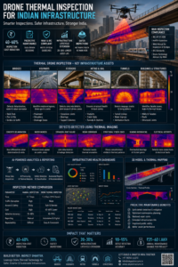
Drone thermography application spectrum in India: a single UAV platform with interchangeable thermal cameras serves energy audits (BEE), solar inspections (IEC 62446-3), building surveys (NBC 2016), agricultural monitoring (ICAR) and wildlife conservation (MoEFCC).
Applications of Drone Thermography
Building Inspections and Maintenance
One of the most common uses of drone thermography is in building inspections and maintenance. By using drones equipped with thermal imaging cameras, professionals can quickly and accurately identify areas of heat loss, moisture intrusion, and insulation deficiencies in buildings. This can help to improve energy efficiency, reduce heating and cooling costs, and prevent potential structural damage.
Electrical Inspections
Another important application of drone thermography is in the field of electrical inspections. Drones can be used to conduct aerial surveys of power lines, transformers, and other electrical infrastructure to detect overheating components and potential faults. This proactive approach to maintenance can help to prevent costly downtime and safety hazards associated with electrical failures.
Environmental Monitoring and Beyond
In addition to building and electrical inspections, drone thermography is also used in environmental monitoring, agriculture, firefighting, search and rescue operations, and more. The ability to capture thermal images from the air provides a unique perspective that is invaluable for identifying hot spots, monitoring wildlife, and assessing environmental changes. Overall, drone thermography has the potential to revolutionize how we gather and analyze thermal data across a wide range of applications.
Benefits of Using Drone Thermography
There are numerous benefits to using drone thermography for various applications. One of the primary advantages is the ability to gather thermal data from a safe distance without the need for physical contact with the object or area being inspected. This reduces the risk of injury or damage to equipment and infrastructure, making it a safer alternative to traditional ground-based thermography.
Furthermore, drone thermography offers a cost-effective and efficient way to conduct thermal surveys over large areas. Drones can cover vast expanses of land or infrastructure in a fraction of the time it would take for ground-based inspections, saving both time and resources. This makes it an ideal solution for industries that require regular monitoring and maintenance of large-scale assets.
Additionally, the high-resolution thermal images captured by drones provide detailed insights into temperature variations that may not be visible to the naked eye. This level of detail allows for more accurate analysis and decision-making when it comes to identifying issues and implementing solutions. Overall, the benefits of using drone thermography extend to improved safety, cost savings, and more comprehensive data collection for a wide range of applications.
FICCI’s 2024 Indian Drone Industry Report estimates India’s commercial drone services market at ₹12,000 crore with thermography inspection comprising approximately 7% (₹840 crore). The thermography segment is growing at 28% CAGR driven by mandatory BEE energy audits, MNRE solar O&M requirements, and increasing insurance industry adoption of thermal risk assessment.
Industries That Can Benefit from Drone Thermography
Drone thermography has the potential to benefit a wide range of industries and sectors. One industry that can greatly benefit from drone thermography is the construction industry. By using drones equipped with thermal imaging cameras, construction professionals can conduct aerial surveys to identify heat leaks, insulation deficiencies, and other thermal anomalies in buildings.
This can help to improve energy efficiency, reduce operating costs, and ensure the longevity of infrastructure. Another industry that can benefit from drone thermography is the energy sector. Drones can be used to conduct aerial inspections of power plants, pipelines, and other energy infrastructure to detect overheating components and potential faults.
This proactive approach to maintenance can help to prevent costly downtime and safety hazards associated with electrical failures. Furthermore, industries such as agriculture, environmental monitoring, firefighting, and search and rescue operations can also benefit from the use of drone thermography. The ability to capture high-resolution thermal images from the air provides valuable insights into temperature variations that can help professionals make informed decisions about maintenance, repairs, and improvements.
Overall, drone thermography has the potential to revolutionize how thermal data is gathered and analyzed across a wide range of industries.
How Drone Thermography Works
Drone thermography works by using drones equipped with thermal imaging cameras to capture infrared radiation emitted by objects or landscapes. These thermal imaging cameras are capable of detecting temperature variations and converting them into visual representations that can be analyzed by professionals. By flying drones equipped with these cameras over buildings, infrastructure, or natural landscapes, professionals can gather valuable thermal data that can be used for a wide range of applications.
The process of drone thermography begins with planning and preparation, where professionals determine the specific areas or objects that need to be inspected. Once the flight plan is established, drones are deployed to capture high-resolution thermal images from the air. These images are then analyzed using specialized software to identify hot spots, cold spots, and other anomalies that may indicate underlying issues.
By interpreting these thermal images, professionals can make informed decisions about maintenance, repairs, and improvements to infrastructure and equipment. Overall, drone thermography provides a non-invasive and efficient way to gather valuable thermal data for a wide range of applications. The ability to capture high-resolution thermal images from the air provides a unique perspective that is not possible with traditional ground-based thermography.
Bureau of Energy Efficiency (BEE) data indicates that facilities using aerial thermal surveys as part of BEE-mandated energy audits identify 25–40% more energy savings opportunities than facilities using only ground-based instruments. The additional savings identified by drone coverage of rooftops, facades, and inaccessible equipment average ₹8–22 lakh per facility for large designated consumers.
Advantages of Using Drones for Thermography
Enhanced Safety and Accessibility
One of the primary advantages is the ability to access hard-to-reach or hazardous areas without putting personnel at risk. Drones can fly over tall buildings, power lines, or other challenging environments to capture thermal images from angles that would be difficult or dangerous for ground-based inspectors to reach.
Cost-Effective and Efficient Aerial Surveys
Drones offer a cost-effective and efficient way to conduct aerial surveys over large areas. They can cover vast expanses of land or infrastructure in a fraction of the time it would take for ground-based inspections, saving both time and resources. This makes it an ideal solution for industries that require regular monitoring and maintenance of large-scale assets.
Comprehensive Data Collection and Analysis
Drones equipped with thermal imaging cameras provide a unique perspective that is not possible with traditional ground-based thermography. The ability to capture high-resolution thermal images from the air allows for more comprehensive data collection and analysis. This level of detail enables professionals to make more accurate assessments and decisions when it comes to identifying issues and implementing solutions. Know more about – How Drone Thermography Is Revolutionizing Building Inspections
Future Trends in Drone Thermography
The future of drone thermography is promising, with several trends emerging that have the potential to revolutionize how thermal data is gathered and analyzed. One trend is the development of advanced thermal imaging technology that offers higher resolution and greater sensitivity. As thermal imaging cameras continue to improve in quality and performance, professionals will be able to capture more detailed thermal images from the air.
Another trend is the integration of artificial intelligence (AI) and machine learning algorithms into drone thermography systems. These technologies have the potential to automate the analysis of thermal images, making it easier for professionals to identify anomalies and make informed decisions about maintenance and repairs. By leveraging AI and machine learning, drone thermography can become even more efficient and accurate in its data collection and analysis.
Furthermore, advancements in drone technology such as longer flight times, increased payload capacities, and improved stability will continue to enhance the capabilities of drone thermography. These developments will enable drones to cover larger areas and capture more comprehensive thermal data with greater precision. Overall, the future trends in drone thermography point towards more advanced technology, improved automation, and enhanced capabilities that will further expand its applications across various industries and sectors.
As these trends continue to evolve, drone thermography will play an increasingly important role in gathering valuable thermal data for a wide range of applications.
If you are interested in learning more about safety audits and inspections, you may want to check out this article on key elements of a successful safety audit checklist. It provides valuable information on how to conduct thorough safety audits to ensure the safety and well-being of employees and the workplace. Safety audits are an important aspect of maintaining a safe and secure environment, and this article offers insights into the essential components of a successful safety audit checklist.
FAQs
What is drone thermography?
Drone thermography is the use of thermal imaging cameras mounted on drones to capture and analyze temperature variations on the surface of an object or area.
What are the applications of drone thermography?
Drone thermography is used in various industries such as construction, agriculture, energy, and infrastructure for applications including building inspections, solar panel inspections, crop health monitoring, and electrical equipment inspections.
What are the benefits of using drone thermography?
The benefits of using drone thermography include the ability to capture high-resolution thermal images from difficult-to-reach areas, identify potential issues before they become major problems, and improve efficiency and safety in inspections and monitoring processes.