Drone thermography combines UAV flight with infrared cameras to detect heat anomalies across large or inaccessible structures in a fraction of traditional inspection time. According to the Bureau of Energy Efficiency (BEE), thermal imaging identifies energy losses averaging 20–30% in industrial facilities, and aerial delivery multiplies coverage area by up to 10x compared to ground-based scans.
Consider a 200,000 sq.ft manufacturing plant in Pune: a ground thermography survey typically costs ₹3–5 lakh and takes 3–4 days, while a drone-based survey covers the same area in 6–8 hours at ₹1.5–2 lakh, generating geo-referenced thermal maps. The Factories Act 1948 mandates periodic electrical inspections, and drone thermography satisfies these requirements while producing DGCA-compliant audit trails.
India’s industrial inspection market is growing rapidly, driven by mandatory energy audits under the Energy Conservation Act 2001 and increasing adoption of IS 1554 / IEC 60364 compliance reviews. Drone thermography is no longer an emerging technology; it is a cost-justified tool for plant managers, facility engineers, and energy auditors across sectors from cement and steel to IT campuses and logistics warehouses.
Drone thermography uses a thermal sensor on a UAV to capture infrared images of assets from above. For solar panels, the drone flies at 30 to 50 metres altitude. For transmission lines, it maintains 20 to 30 metres standoff from the conductor. Effective inspection requires irradiance above 600 W/m2 for solar, wind below 7 m/s for all assets, and a calibrated 640×512 sensor.
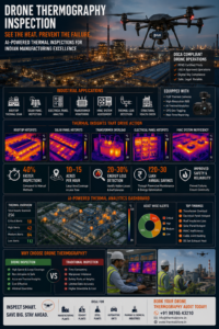
A commercial UAV equipped with a FLIR thermal camera performs aerial thermography over a Pune manufacturing plant, detecting heat anomalies invisible to ground-based inspection.
Why Aerial Thermography Solves What Ground Inspection Cannot
Thermal imaging from the ground has a fundamental limitation: you can only inspect what you can see at a useful angle. For a rooftop solar array, a ground-based thermal camera captures modules at a steep angle, introducing emissivity errors and missing large sections of the array. For a high-voltage transmission tower with a conductor 50 metres above, a handheld thermal camera is impractical and potentially dangerous.
Mounting a thermal sensor on a drone solves both problems. The drone positions the camera at an optimal angle above the target, covers large areas in systematic passes, and keeps personnel away from hazardous assets. This is why aerial thermography has become the standard inspection method for solar O&M teams and transmission utilities across India.
Know More about- From Thermography Test Procedure to Audit Report – Elion Sets the Benchmark
The Physics — Why Thermal Drones Work
Every object emits infrared radiation proportional to its temperature. A thermal camera measures this radiation and converts it to a temperature map. When a solar module has a failed bypass diode, that sub-string dissipates energy as heat rather than converting it to electricity. The temperature difference between the faulty sub-string and its functioning neighbours can be 10 to 40 degrees Celsius — clearly visible at 40 metres altitude with a 640×512 sensor.
For transmission line components, resistance heating follows the power equation P = I squared times R. A corroded splice joint with 10 times the normal contact resistance dissipates 10 times more heat at the same current. At 400kV, even a small resistance increase generates significant heat detectable at standard inspection altitude.
Equipment Requirements for Accurate Aerial Thermography
| Parameter | Minimum for Solar | Recommended for Solar | Transmission Lines |
| Thermal resolution | 320×240 pixels | 640×512 pixels | 640×512 with telephoto lens |
| NETD | Below 80mK | Below 50mK | Below 50mK |
| Calibration | Annual | Annual | Annual plus field check |
| Altitude | 30 to 50 metres | 30 to 40 metres | 20 to 30m from conductor |
| Flight speed | Below 5 m/s | 3 to 4 m/s | 2 to 3 m/s |
| Pass overlap | 20% minimum | 30% | 30% |
Inspection Conditions — What Affects Data Quality
For Solar Panel Inspection
- Irradiance: minimum 600 W/m2 measured at ground level
- Wind: below 7 m/s at inspection altitude — higher wind cools surfaces and reduces thermal contrast
- Time of day: 10 AM to 3 PM IST for optimal sun angle in most Indian locations
- Module cleanliness: post-rain or post-cleaning inspections give the most reliable data
- Do not inspect within 24 hours of rain — wet surfaces have different emissivity characteristics
For Transmission Line Inspection
- Load current: higher load means resistive heating is more pronounced at fault points — inspect during peak demand when possible
- Wind: below 5 m/s preferred — convective cooling reduces delta-T at fault points
- Early morning: for corona activity signatures, pre-dawn inspections reveal corona more clearly than midday
- Coordinate with utility: load dispatch must not change switching during the inspection window
From Raw Images to Actionable Report
Raw thermal images from a drone inspection are not a report. Every image must be reviewed, anomalies identified, delta-T values measured, and findings classified by severity. On a 10MW solar plant, a single inspection generates 3,000 to 5,000 thermal images. Our analysts process these using thermal analysis software, generate GPS-tagged anomaly records, and cross-reference each finding with the plant layout map to assign module IDs.
The final report maps every finding to a physical location on the plant, making it immediately actionable for the O&M team. Every anomaly has a GPS coordinate, a severity class, and a recommended action — no ambiguity.
Know More about – Preventive vs Reactive Maintenance – Role of Thermography & Arc Flash Safety Audits